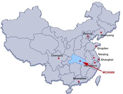
China Array Plastics
ddddddA Full Service Custom Injection Molder of High Performance Thermoplastics
ddddddManufacturing in China Since 1980
 
Home
Molding:
Injection Molding
Performance Polymers
Molds
Prototypes
Post Molding/ Accessories
Quality Control
CAD/CAM
Customers:
OEM's
Distributors
Designers
Intellectual Property
Applications
Company:
Management
History
Wuhan, China
Press
Photos
Contact Us
Quotations
China's Industrial Heartland: The Central Yangtze River Valley

The coastal cities of Shanghai, Guangzhou and Shenzhen receive most of the publicity for China's economic miracle. However, China Array's historic base is in the Central Yangtze River Valley, an area 400 miles inland from Shanghai. Coincidences of history and geography conspire to provide this region of China with the best manufacturing facilities and the most technically competent labor force in the country.

Because China Array's first business dealings were with the China State Shipbuilding Corporation (CSSC), a major state owned enterprise and one of the few Chinese companies allowed to work with foreign firms when China first opened to the west, China Array was assigned to work with factories located in the Yangtze River Valley. It has had a continuous presence there since 1980.

While the interior of China has lagged behind the coastal regions, it has maintained its industrial base, engineering capabilities, and high caliber labor. In recent years it has made tremendous strides in economic development. The region is far enough removed from the economically hyperactive east coast of China to have retained relatively low labor costs. The combination of premiere manufacturing capacity, high caliber engineering talent and low labor rates has created a unique opportunity for the production of value-added industrial products. And, since the region was one of the first areas to work with foreign firms, its factories have a tradition of meeting international standards, such as ISO 9000 and above: particularly in industrial goods.

Wuhan, China— the Geographic, Economic & Cultural Center Of China

Wuhan is the capital of Hubei province, and is the most populous city in central People's Republic of China. It lies at the east of Jianghan Plain, and the intersection of the middle reaches of the Yangtze and Han River. Arising out of the conglomeration of three boroughs, Wuchang, Hankou, and Hanyang, Wuhan is known as the "thoroughfare of nine provinces"; it is a major transportation hub, with dozens of railways, roads and expressways passing through the city. The city of Wuhan, first termed as such in 1927, has a population of approximately 9,100,000 people (2006), with about 6,100,000 residents in its urban area. In the 1920s, Wuhan was the capital of a leftist Kuomintang (KMT) government led by Wang Jingwei in opposition to Chiang Kai-shek, now Wuhan is recognized as the political, economic, financial, cultural, educational and transportation center of central China.

Wuhan is a sub-provincial city. Its GDP was RMB 396 billion and GDP per capita was approximately RMB 44,000 (US$6,285) as of 2008. In 2008, the city's average disposable income was 16,360 yuan.[citation needed] Wuhan is an important functional center for economy, trade, finance, transportation, information and technology, and education in Central China. Its major sectors include modern manufacture industry with optic-electronic information, automobile manufacture as the key components, steel manufacturing, new pharmaceutical sector, biology engineering, new material industry, environmental protection. Wuhan Iron & Steel (Group) Co. and Dongfeng-Citroen Automobile Co., Ltd settle in this city.

Wuhan is the scientific and educational center in Central China, with 35 higher educational institutions such as Wuhan University and Huazhong University of Science and Technology, which cover all the fields of science and technology and employ elites and explorers in these fields. Wuhan has formed a comprehensive scientific and educational strength ranking the 3rd in China with its main force: three national development zones and four scientific and technologic development parks as well as numerous enterprise incubators, over 350 research institutes, 1470 hi-tech enterprises, and over 400,000 experts and technicians. There are eight national colleges and universities, and fourteen public colleges and universities in Wuhan.
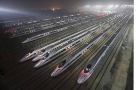
The United States, France, and soon, South Korea each have a consulate in Wuhan. The U.S. Consul General, the Honorable Ms. Wendy P. Lyle, has been stationed in Wuhan since 30 November 2007. The office of the U.S. Consulate General, Central China (located in Wuhan) celebrated its official opening on 20 November 2008 and is the first new American consulate in China in over 20 years. Wuhan has currently attracted about 50 French companies, over one third of French investment in China, the most among Chinese cities.

Geography and Climate

Wuhan is situated in the middle of Hubei Province of China, East Longitude 113°41'-115°05', North Latitude 29°58'-31°22'.the east of Jianghan Plain, and the confluence of the middle reaches of the Yangtze River and Hanshui River. The metropolitan area comprises three parts - Wuchang, Hankou, and Hanyang, commonly called the "Three Towns of Wuhan" (hence the name "Wuhan", combining "Wu" from the first city and "Han" from the other two). The consolidation of these three cities occurred in 1927 and Wuhan was thereby established. These three parts face each other across the rivers and are linked by bridges, including one of the first modern bridges in China, known as the "First Bridge". It is simple in geographical structure - low and flat in the middle and hilly in the south, with the Yangtze and Han rivers winding through the city. Wuhan occupies a land area of 8494.41 km2, most of which is plain and decorated with hills and a great number of lakes and pools. Wuhan's climate is a subtropical monsoon one with abundant rainfall and distinctive four seasons. Wuhan is known for its oppressively humid summers, when dewpoints can often reach 26? or more.[1] Because of its hot summer weather, Wuhan is known as one of the Three Furnaces of China, along with Nanjing and Chongqing. Wuhan is by far the hottest of the Three Furnaces; the average temperature in July is 37.2°C (99°F), and the maximum often exceeds 40°C (104°F).[citation needed] Spring and autumn are generally mild, while winter is cool with occasional snow. In recent thirty years, the average annual rainfall is 1269 mm, mainly from June to August; annual temperature is 15.8?-17.5?, annual frost free period lasts 211 to 272 days and annual sunlight duration is 1810 to 2100 hours.

Transportation

The First Bridge at Wuhan, also called the First Bridge, was built over the Yangtze River (Chang Jiang) in 1957, carrying the railroad directly across the river between Snake Hill (on the left in the picture below) and Turtle Hill. Before this bridge was built it could take up to an entire day to barge railcars across. Including its approaches, it is 5,511 feet (1680 m) long, and it accommodates both a double-track railway on a lower deck and a four lane roadway above. It was built with the assistance of advisers from the Soviet Union.

The Second Bridge, a cable-stayed bridge, built of pre-stressed concrete, has a central span of 400 meters; it is 4,678 meters in length (including 1,877 meters of the main bridge) and 26.5 to 33.5 meters in width. Its main bridgeheads are 90 meters high each, pulling 392 thick slanting cables together in the shape of double fans, so that the central span of the bridge is well poised on the piers and the bridge's stability and vibration resistance are ensured. With six lanes on the deck, the bridge is designed to handle 50,000 motor vehicles passing every day. The bridge was completed in 1995.

The Third Bridge, or Third Wuhan Changjiang Bridge was completed in September 2000. Located 8.6 kilometers southwest of the First Bridge, construction of Baishazhou Bridge started in 1997. With an investment of over 1.4 billion yuan (about 170 million U.S. dollars), the bridge, which is 3,586 meters long and 26.5 meters wide, has six lanes and has a capacity of 50,000 vehicles a day. The bridge is expected to serve as a major passage for the future Wuhan Ring Road, enormously easing the city's traffic and aiding local economic development.

The city proper in Wuhan is served by two railway stations located in the boroughs of Hankou and Wuchang. As a result, the railway system in China actually does not have a unique designation for the name "Wuhan", and trains heading to Wuhan are marked with the respective borough's station name, and not the city's. In 2006, construction began on the new Wuhan Railway Station with 11 platforms. New high-speed trains from Shanghai to Wuhan to Chongqing (East/West Axis) and from Beijing to Wuhan to Hong Kong (North/South Axis) are scheduled for completion in 2011, placing Wuhan within a five hour train ride to the other major population centers in China.

In September 2004, Wuhan became the sixth Chinese city with a subway system (after Beijing, Tianjin, Shanghai, Guangzhou and Shenzhen). The first 10.2 km line (10 stations) is an elevated rail (and therefore called 'light rail' in Chinese terminology). It runs from Huangpu to Zongguan in the downtown area of the Hankou District, and it is the first one in the country to use a communication-based train control system (a Moving Block signalling system, provided by Alcatel). The designed minimum interval is only 90 seconds between two trains and it features driverless operation.

Wuhan Tianhe International Airport Opened in April 1995, Wuhan Tianhe International Airport is one of the busiest airports in central China and it is located 26 km north of Wuhan. It has also been selected as China's fourth international hub airport after Beijing Capital International Airport, Shanghai-Pudong and Guangzhou Baiyun. A second terminal was completed in July 2008, having been started in February 2005 with an investment of RMB3.372 billion.


Copyright © 2001 China Array & ChinaArray.com: All rights reserved.